What nobody tells you about the Atlas Mountains
The Instagram gap is wider here than anywhere
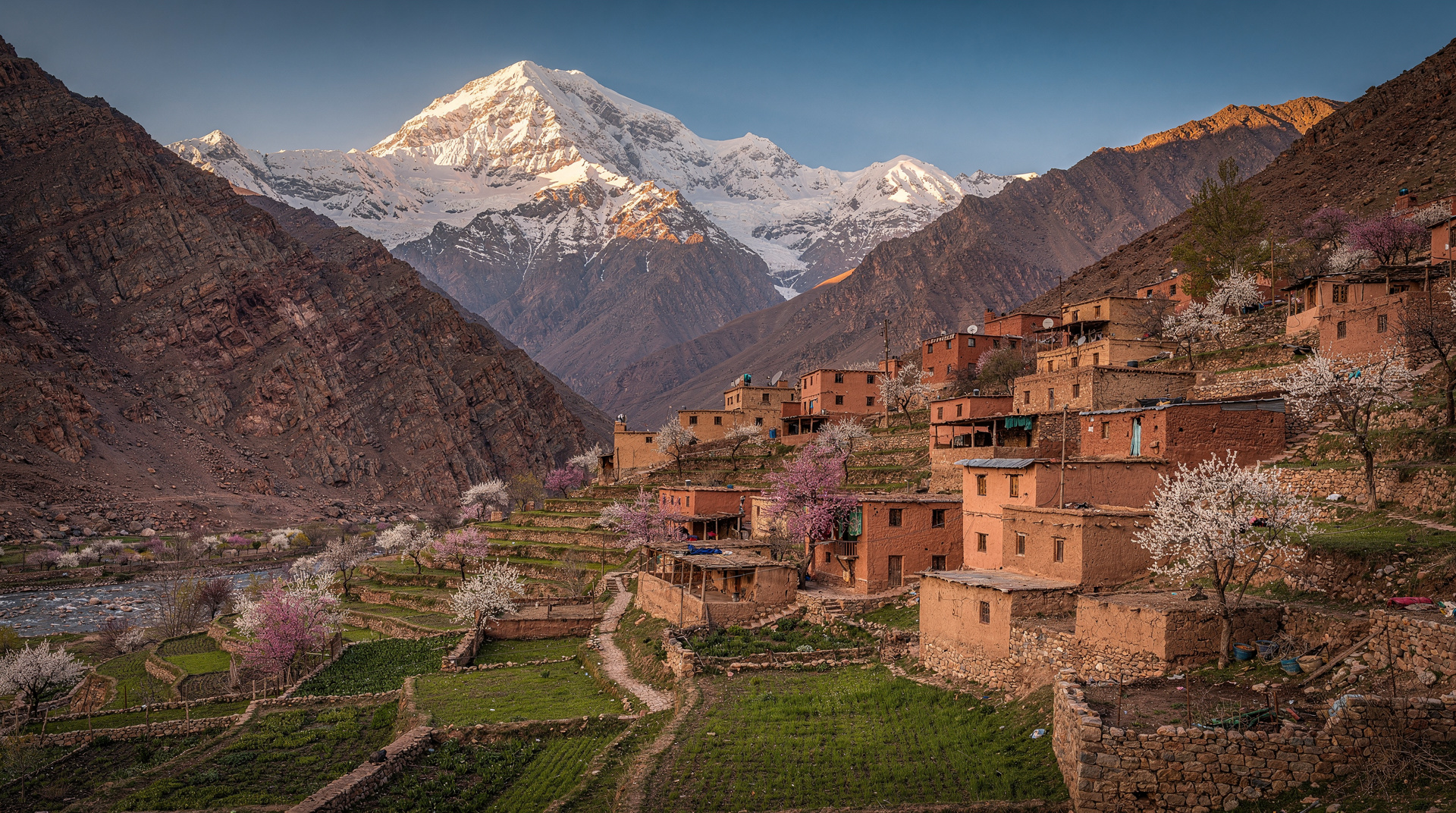
The Atlas Mountains are the second most photographed thing in Morocco after the Sahara dunes, and they suffer from an even wider gap between expectation and reality. The photograph — terraced Berber villages, mule tracks through wildflower meadows, snow peaks above green valleys — is real. That landscape exists. What is absent from the photograph: the altitude headache at 2,000 metres when you have come from sea level, the sudden afternoon thunderstorm that was not forecast, the muleteer negotiation that turns your peaceful trek into a commercial transaction, and the cost of a two-day hike that, fully reckoned, is not as cheap as the day-trip flyers on the Marrakech medina wall suggest.
I am not discouraging you from going. The Atlas rewards every traveller who goes prepared. I am saying that prepared means something specific here.
The altitude is real
Imlil — the most common base for Atlas treks, 60 km southeast of Marrakech — sits at 1,740 m. The Toubkal refuge, where most people sleep before their summit attempt, is at 3,207 m. Toubkal’s summit is at 4,167 m, the highest point in North Africa.
Marrakech, where most visitors to the Atlas have come from, sits at 466 m. You gain roughly 1,300 m of altitude just getting to the Imlil valley floor, and another 1,500 m before you get to the refuge.
For the majority of hikers who are not high-altitude regulars, this produces effects that range from a mild headache and shortness of breath to genuine altitude sickness — nausea, disorientation, severe headache, and in rare cases more serious symptoms. The key mistake is going too fast. Day-trippers who arrive at Imlil by taxi at 9 am with the ambition of reaching 3,000 m and back by 5 pm are routinely surprised by how bad they feel at 2,500 m.
The standard mitigation is the standard one: ascend slowly, drink significantly more water than you think you need, eat lightly on summit day, and descend if symptoms worsen rather than improve. If you are doing a multi-day hike, spend your first night at a lower elevation — there are good gîtes (mountain guest houses) in the Imlil valley — before ascending higher.
The Toubkal summit is genuinely achievable for fit, non-technical hikers. But fit at sea level and fit at 4,000 m are different things, and nobody should underestimate the gap.
Weather swings are violent and fast
In April in the High Atlas, you can have 22°C and blue skies at 9 am and be caught in a hailstorm at 2 pm at 3,000 m. In July, the same thing happens with thunderstorms rather than hail. In winter (November–March), snow is regular above 2,000 m and can close the Tichka pass and the Imlil road without warning.
The Atlas weather is local, meaning it does not track well with the forecasts you get from Marrakech-based weather apps. The mountains create their own micro-systems. A guide from the Imlil village will know, from the cloud formation on the Toubkal massif that morning, whether the afternoon is safe. A weather app that says “partly cloudy” tells you much less.
Practical rules:
- Start ascents early. Be descending by 1 pm on summit days.
- Carry a wind layer and rain layer regardless of morning conditions.
- Accept that your summit attempt may need to be postponed or abandoned. The mountain will be there when the weather clears.
- In winter: hire a local guide who knows the current snow conditions. Crampons and an ice axe may be needed for Toubkal above 3,500 m.
The muleteer situation
Every multi-day Atlas trek involves mules. The terrain above Imlil is too steep for wheeled transport; most villages are accessible only on foot or by mule. The mules carry camping equipment, food supplies, and — if you need it — hikers who cannot complete the ascent on foot.
What visitors are often not told before they arrive is that the muleteer economy operates on negotiated daily rates that are set locally, subject to significant variation, and almost always higher than whatever figure you have read online or seen on a tour-operator flyer. The muleteers are self-employed, often the primary income earner for a family, and they know exactly what tourists are willing to pay.
The baseline rate for a muleteer with one mule for a single day is currently around 250–350 MAD per muleteer, plus 150–200 MAD per mule, plus tip. For a two-day Toubkal circuit with two people, a muleteer, a guide, camp equipment, and food, you are looking at 1,500–2,500 MAD (130–220 euros) per person, minimum, done honestly. Operators who quote 50 euros for the full Toubkal circuit are either lying about inclusions or paying their muleteers badly.
This is not a complaint against the muleteers. Their work is physically demanding, their animals require feeding and care, and their rates are justified. It is a complaint against the marketing that under-prices the Atlas experience and leaves travellers feeling either deceived or guilty when the real costs emerge.
What to do: book through a licensed guide from the Imlil Bureau des Guides, agree all costs upfront in writing (a receipt is reasonable to request), and tip proportionally to what the work was worth. The muleteers and mountain guides of Imlil are excellent at their jobs and have been taking foreigners up Toubkal for a hundred years.
The day trip is a different thing from the trek
A significant proportion of Atlas visitors come on a day trip from Marrakech — three to four hours of walking in the Imlil valley, a Berber village, a lunch, and back. This is a lovely experience. It is not the same as a multi-day trek and should not be sold as one.
A day trip to Berber villages in the Atlas from Marrakech gives you the valley, the architecture, a lunch, and a sense of the scale. It will not give you altitude, summit views, or the experience of waking up in a mountain refuge at dawn with the massif entirely to yourself.
Both are valid. But someone who books a day trip expecting a mountain adventure, and someone who books a two-day Toubkal circuit expecting a gentle walk, are both going to be disappointed. Know which one you are paying for.
The village accommodation reality
The gîtes of the Imlil valley range from genuinely excellent to rudimentary in ways that can surprise unprepared hikers. A good gîte offers: a clean mattress, blankets (essential above 2,000 m even in summer), a squat toilet, a common room with a wood stove, and dinner and breakfast included. A bad gîte offers a cold room, thin blankets, and a bathroom situation I will not describe.
The Refuge du Toubkal, run by the Club Alpin Français, is the best-known high-altitude option — comfortable, with reliable food and a solid track record. Booking ahead (it fills up in April–May and August) is advisable.
In Imlil itself, the accommodation has improved substantially in recent years. There are now several well-run guesthouses that offer heated rooms, private bathrooms, and surprisingly good food. Chez Momo is a long-standing favourite; the newer Atlas Guesthouse is also consistently well-rated.
Prices range from 200–400 MAD per person for a gîte with half board (dinner and breakfast). This is genuinely affordable and the food — a tagine at 2,000 m after a long day of hiking — is among the most satisfying meals you can eat in Morocco.
What nobody mentions: the valleys themselves
The standard narrative of the High Atlas focuses on Toubkal — highest peak, big objective, clear summit story. But the valleys below the summit zone are actually where the most interesting travel happens, and they are significantly underrepresented in the standard tourist literature.
The Aït Bougmez valley (“the happy valley”), the Tessaout Valley, the Amezmiz area south of Marrakech — all offer multi-day walking through Berber villages, walnut orchards, and terraced fields that see a fraction of the traffic of the Imlil-Toubkal corridor. The landscapes are as beautiful. The villages are more genuinely inhabited. The tourist infrastructure is thin but real.
Getting to these valleys requires either a private car or taxi, or local transport from Marrakech that can involve long waits and uncertain schedules. A guide from Imlil who knows the wider Atlas is worth hiring for exactly this reason — they know the valleys, the paths, the gîtes, and the local family contacts that turn a walking trip into something genuinely memorable.
Our Atlas Mountains destination guide maps the main routes and valleys.
The Imlil to Toubkal reality check
For anyone planning the Toubkal summit, here is the honest version:
- Day 1: Transfer from Marrakech to Imlil (about 1.5 hours by grand taxi, 60–80 MAD per seat). Acclimatise in Imlil. Short walk to Aremd village if energy allows. Sleep at a gîte in Imlil (1,740 m).
- Day 2: Early start (7 am) to Toubkal refuge (3,207 m), 4–5 hours. The path is clear and well-marked. Expect altitude effects above 2,500 m. Sleep at the refuge.
- Day 3: Summit day. Start at 5 am. Summit (4,167 m) reached in 3–4 hours depending on conditions. Descend to Imlil by late afternoon.
This three-day structure allows reasonable acclimatisation and does not require rushing. Attempting it in two days — overnight from Marrakech, summit next morning, back to Marrakech the same evening — is possible for fit hikers but leaves very little margin for weather or health.
An Atlas Mountains day trip covering three valleys and waterfalls is the right entry point if you want to see the landscape without committing to a summit attempt.
The bottom line
The Atlas Mountains are worth the effort. The honest effort. Not the marketed effort that promises everything in a day and delivers a rushed lunch and a vague view of some hills.
Go with a realistic itinerary, appropriate gear, honest expectations about cost, and time to let the altitude adjust. Go to the valleys as well as the summits. Hire local guides not just for navigation but for context — the Berber communities of the Atlas have a culture, a language, and a relationship with this landscape that is invisible from the tourist literature and visible immediately in person.
The Atlas is where Morocco’s tourism hype encounters its most honest landscape. The mountains will give you exactly what you come prepared to receive.
Our hiking and trekking guide for Morocco has detailed itinerary options for various fitness levels and timeframes, and our Atlas Mountains destination guide covers the regional context.