Toubkal trek guide: the 2-day route to North Africa's highest peak
How hard is the Toubkal trek and how long does it take?
The standard 2-day Toubkal trek is rated moderate-to-strenuous. Day 1 is a 4-5 hour hike from Imlil to the refuge at 3,207m. Day 2 is a 3-4 hour ascent to the summit at 4,167m and descent back. Total elevation gain is approximately 2,000m.
Morocco’s highest mountain, in 2 days from Marrakech
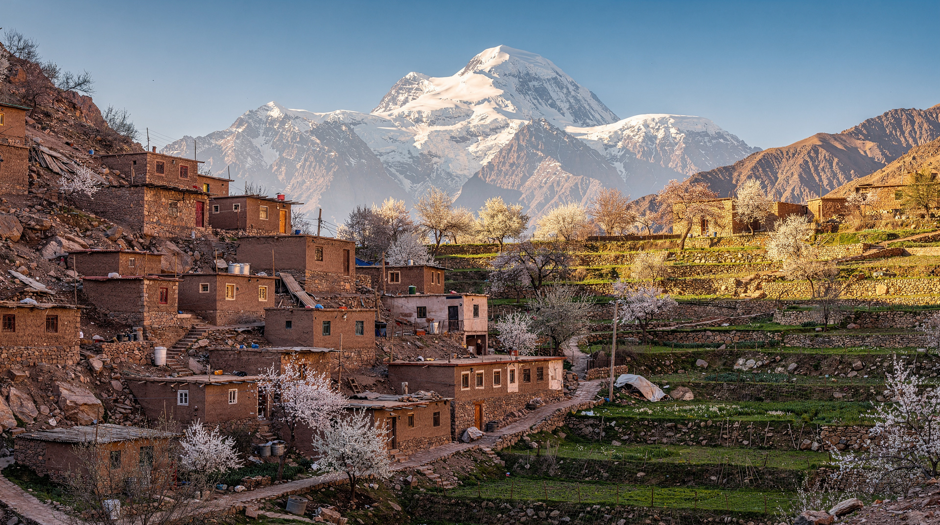
Mount Toubkal at 4,167m is the highest peak in the Atlas Mountains and the highest in North Africa. It sits 75km south of Marrakech and is accessible via a paved road to the village of Imlil, where the standard trek begins. From Marrakech to summit and back takes 3 days total (1 day driving and first-day hiking, 1 day summit, 1 day descent and return to Marrakech).
The standard route is well-established, clearly waymarked in its lower sections, and does not require technical climbing skills. What it does require is solid aerobic fitness, appropriate gear for mountain conditions, and respect for altitude — 4,167m is high enough for altitude sickness to affect unprepared trekkers.
This guide covers the complete 2-day trek from Imlil: the day-by-day itinerary, difficulty assessment, when to go, guide requirements and costs, and the gear list.
How to get to Imlil from Marrakech
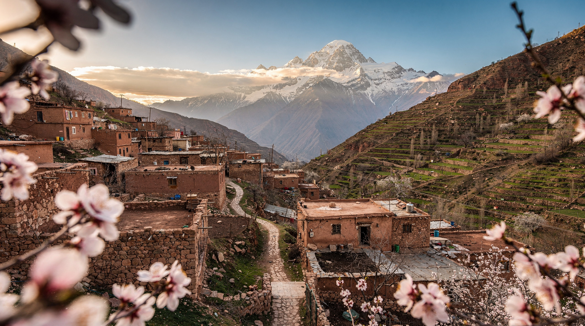
Imlil is the standard starting point. It sits at 1,740m elevation, 75km south of Marrakech.
By private transfer or taxi: The most efficient option. A grand taxi from Marrakech costs 300-400 MAD (30-40 EUR) for the vehicle. Journey time is approximately 1.5 hours on the P2017 road. Private transfer can be arranged through your riad or guesthouse.
By public transport: Shared grand taxis run from Marrakech’s Bab er-Rob station to Asni (45 minutes, 25-30 MAD per seat), then another shared taxi from Asni to Imlil (20 minutes, 15-20 MAD per seat). This works but involves transfer time and can be slow with waiting.
Day trip basis from Marrakech: The Atlas Mountains day trip from Marrakech covers the Imlil area and lower valley with transport included — useful for those doing the day-hike version rather than the full 2-day trek.
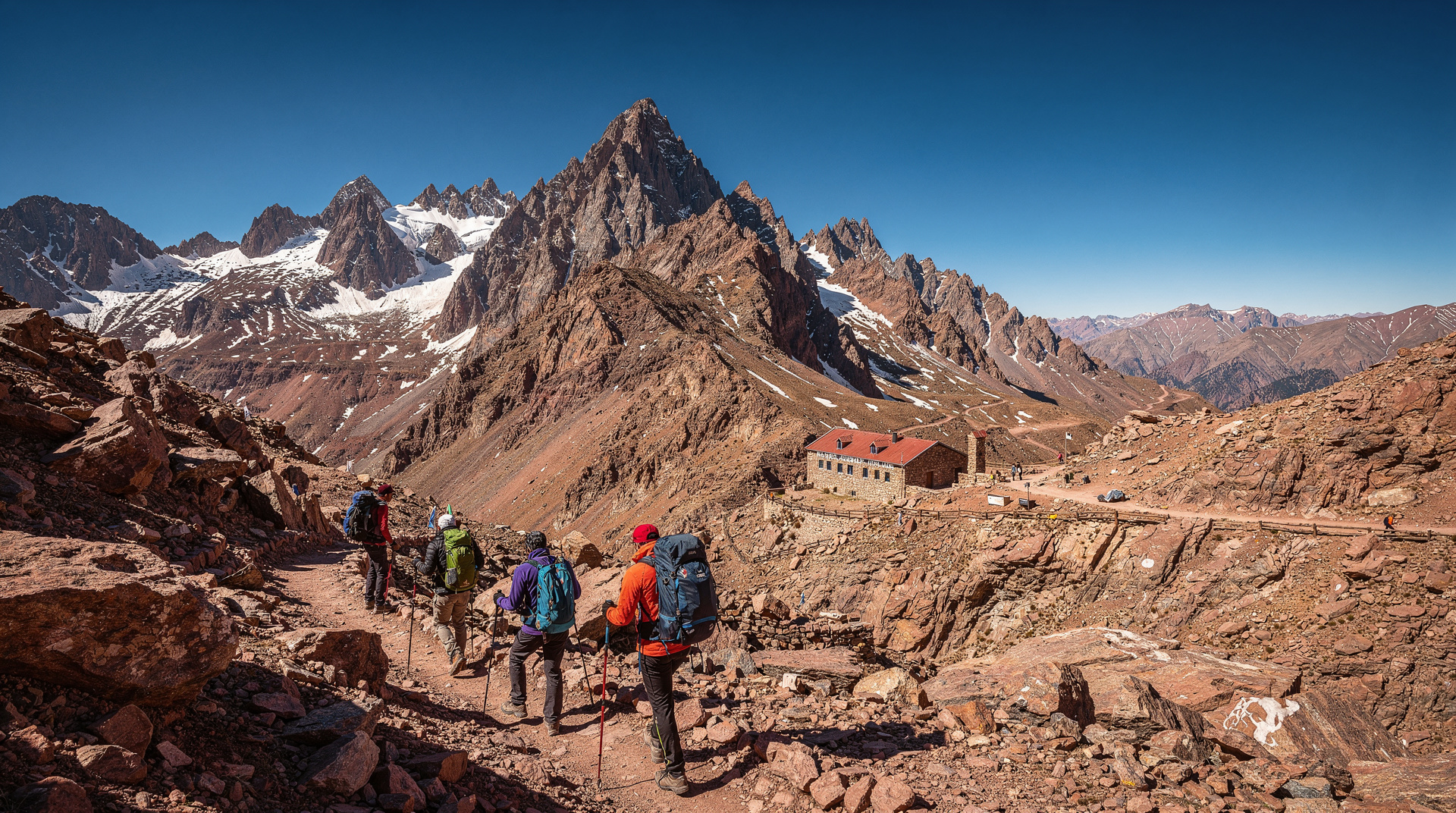
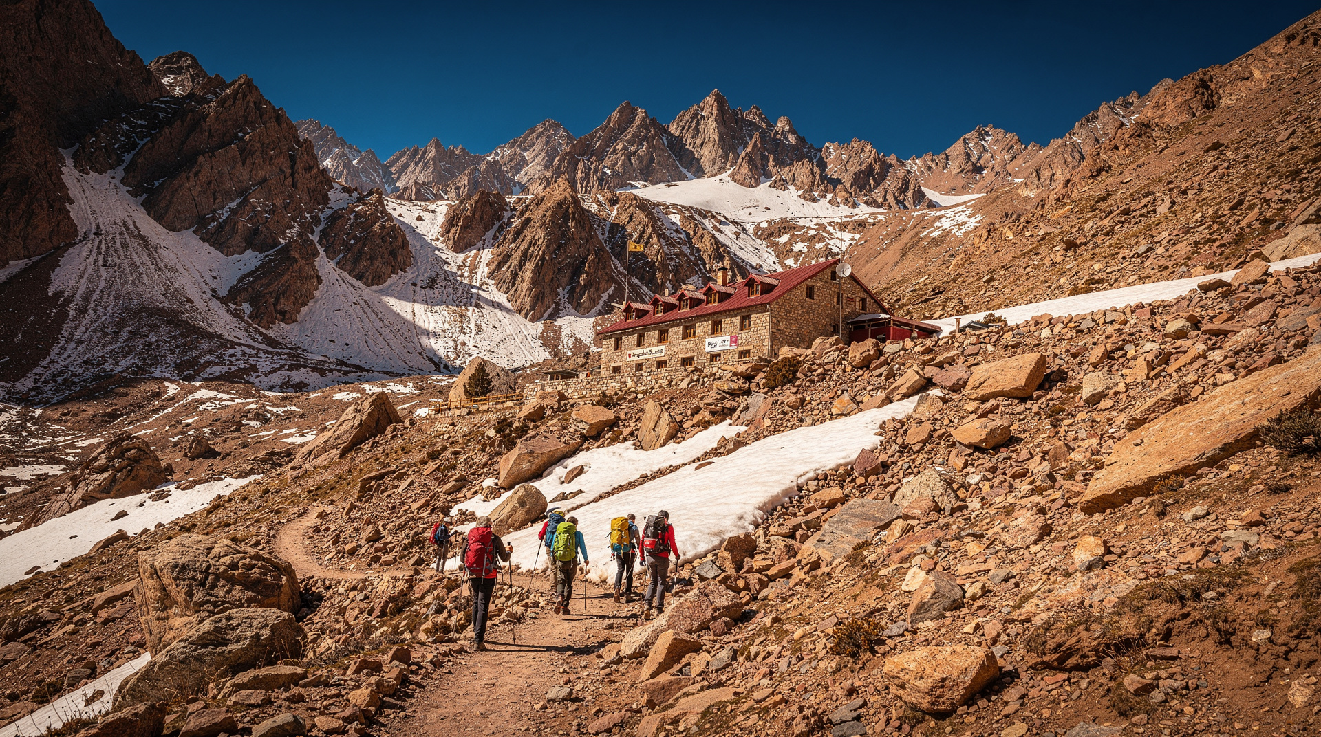
Day 1: Imlil to Toubkal refuge
Distance: 12km one-way Elevation gain: Approximately 1,467m (Imlil 1,740m to refuge 3,207m) Duration: 4-5 hours moving time Difficulty: Moderate-strenuous
The route from Imlil begins in the village centre, following the valley of the Mizane River upstream through the hamlet of Aroumd (1,840m), which offers the last reliable supplies and tea houses before the refuge. From Aroumd the trail becomes steeper, climbing through a zone of large boulders and scrub into open rocky terrain.
Key section: the 3,000m marker — Around the 3,000m mark, the route crosses more exposed ground. Here the altitude begins to matter. If you’re feeling headaches, unusual breathlessness, or dizziness, slow down and rest. This is the altitude acclimatisation zone where problems first appear.
Toubkal Refuge (3,207m): The CAF (Club Alpin Français) refuge operates April through October with dormitory beds and meals. It’s basic but functional — a mountain hut with bunks, blankets, a kitchen producing simple hot meals (tagine, soup, bread), and running water. Alternatively, the Toubkal Refuge (a separate nearby operation) provides slightly more comfortable accommodation.
Book the refuge in advance during busy periods (July-August, weekends in spring/autumn). Available online through CAF Maroc or directly. Cost: approximately 250-300 MAD per person per night for a dormitory bed.
The Neltner basin at the refuge level is worth exploring in the afternoon after arrival: a dramatic glaciated cirque with excellent light at sunset. Rest here rather than pushing further — the summit ascent starts at 5:30-6:00am the next day.
Day 2: Summit day and descent
Summit distance from refuge: 5km one-way Elevation gain: 960m (refuge 3,207m to summit 4,167m) Duration: 3-4 hours ascent, 2-3 hours descent to refuge, 3-4 hours descent to Imlil Total Day 2 hiking: 8-10 hours
Predawn start: Most trekkers depart the refuge at 5:30-6:00am to reach the summit before 10am. This timing serves two purposes: avoiding afternoon cloud buildup that can obscure views, and completing the descent before afternoon sun makes the rock slabs uncomfortably hot.
The ascent route: From the refuge, the trail crosses the basin floor and climbs a scree slope of loose shale and rock to the South Cwm (around 3,900m). This scree section is the most physically demanding part of the ascent — 2 steps forward, 1 step back in places. Poles help significantly on this section.
From South Cwm, the route follows a rocky ridge to the summit pyramid. This section is more technical in winter with ice (crampons required November-March), but in summer is a steep rock walk without exposed scrambling.
The summit: A metal pyramid, a summit register, and on clear days, views extending south across the pre-Saharan plains and north across the full Atlas range. Early-morning visibility in spring is often exceptional — distances of 200-300km are possible.
Descent to Imlil: 5-7 hours depending on pace. The descent is harder on the knees than the ascent. Trekking poles, if you have them, pay back here. Most trekkers are back in Imlil by 4-6pm.
Difficulty assessment
Physical fitness requirement: The 2-day Toubkal trek requires solid aerobic fitness. If you can comfortably walk 20km over varied terrain in a single day, you’re within range. This is not a casual hike. The cumulative 4,000m+ elevation change over 2 days is the primary challenge.
Technical difficulty: Low in summer. The route is a walk (with poles), not a climb. No ropes, harnesses, or technical skills required April-October. The steep scree section is demanding but not technically difficult.
Altitude consideration: 4,167m is genuinely high. Acute Mountain Sickness (AMS) can affect anyone at this elevation, regardless of fitness level. Symptoms: headache, nausea, dizziness, loss of appetite. Prevention: ascend slowly, hydrate aggressively, don’t push through symptoms. If AMS symptoms worsen rather than improve with rest at the refuge, descend — not continue up.
Winter conditions (November-March): A completely different proposition. Snow on the upper mountain from November onwards, ice on the south cwm and summit sections. Crampons and ice axes are mandatory. A qualified mountain guide is essential. The difficulty increases from moderate-strenuous to genuinely challenging. See the Toubkal summit guide for the full winter and altitude-specific breakdown.
When to go
Best months: April to October. The trail is snow-free, the refuge is open, and conditions are safe without specialist equipment.
Optimal windows within the season:
- April-May: Late snow possible but generally clear by mid-April. Wildflowers in the lower valleys are exceptional. Moderate crowds.
- June: Excellent conditions. Before peak summer heat hits the lower trail.
- July-August: Peak season. The upper mountain is hot during the day. The trail is busy with international trekkers. Book the refuge well in advance.
- September-October: The best overall window. Temperatures are comfortable throughout, crowds thin significantly, and autumn light is excellent for photography.
Avoid for standard route: November-March unless you have winter mountaineering experience and equipment (crampons, ice axe) and a qualified mountain guide.
Guide requirements and what you actually need
In Morocco, hiring a guide for Toubkal is legally recommended (and strongly advisable) but not strictly mandatory. The situation is nuanced:
The argument for a guide:
- Route-finding in cloud or mist above the refuge is non-trivial
- Local guides know current conditions on the upper mountain
- A guide handles logistics (refuge booking, mule hire if needed, village introductions)
- Emergency response — having an experienced local with you when altitude sickness or injury occurs is significant
The argument against (for experienced trekkers):
- The main route is well-used and clearly visible in good conditions
- Above 3,000m, waymarking exists (cairns, painted rocks in places)
- Experienced mountain trekkers with navigation ability and adequate gear can safely complete the standard route in summer
The practical reality: First-time trekkers, those without mountain experience, and anyone going outside April-October should hire a guide. Experienced trekkers comfortable in mountain environments can do it independently in summer — but most still hire guides and find the cultural and logistical value worth the cost.
Guide cost (2026): Licensed mountain guides cost 400-600 MAD per day (40-60 EUR). A 2-day Toubkal trek with a shared group guide costs approximately 300-400 EUR per person all inclusive. Private guide plus all logistics runs 500-700 EUR per couple.
Gear list for the 2-day trek
Essential:
- Hiking boots with ankle support (not trail runners — the scree requires proper footwear)
- Trekking poles (significantly reduce knee strain on descent)
- Warm layering: base layer, insulating mid-layer, windproof outer shell
- Hat for sun (on the climb) and warmth (at the refuge)
- Gloves (summit temperatures can be near 0°C even in summer)
- Sunscreen SPF 50+ (altitude UV is intense)
- Headtorch (for predawn summit start)
- 2-3L water capacity (water is available at the refuge but not on the upper mountain)
- Snacks: nuts, dried fruit, energy bars for the summit day
Recommended:
- Sleeping bag liner (refuge blankets are provided but basic)
- Gaiters (for scree section)
- Knee supports if you have any history of knee problems
Not needed for summer:
- Crampons (unless you encounter unexpected late-season snow above 3,500m — rare April-October)
- Ice axe (summer only; essential November-March)
Costs breakdown (2026)
| Item | Approximate cost |
|---|---|
| Transfer Marrakech → Imlil | 300-400 MAD (taxi) |
| Guide (2 days) | 800-1,200 MAD (80-120 EUR) |
| Mule for luggage (optional) | 200-300 MAD/day |
| Refuge accommodation | 250-300 MAD/person/night |
| Refuge meals | 80-150 MAD per meal |
| National park entry | 20-30 MAD |
| Total per person (guided, 2 days) | 1,500-2,500 MAD (150-250 EUR) |
Organised tour packages (Marrakech base, transport, guide, refuge included) run 130-200 EUR per person for shared groups, 400+ EUR for private.
Connecting Toubkal to the rest of your Atlas itinerary
The Imlil area is rich in hiking options beyond the Toubkal summit. The Berber villages tour guide covers the lower Atlas valleys — Aroumd, Setti Fatma, and Ouirgane — which make excellent additions to a Toubkal trip or standalone day hikes from Marrakech. For longer Atlas treks beyond Toubkal, the multi-day Atlas trek guide covers the Toubkal Circuit and M’Goun Traverse.
The Atlas Mountains destination guide covers the full regional context, including how to combine a Toubkal trek with other High Atlas activities in a 5-7 day itinerary.
Frequently asked questions
Do I need to be experienced to do Toubkal?
No specific mountain experience is required for the summer route. Good aerobic fitness and proper gear are more important than technical skills. First-time mountain hikers with hiking experience complete the route regularly with a guide.
How cold is it at the summit?
Even in August, summit temperatures can be 5-15°C with wind chill. In September-October, expect 0-5°C at the summit. Bring warm layers regardless of the season — the difference in temperature between Imlil (1,740m) and the summit (4,167m) is dramatic.
Is there altitude sickness risk?
Yes, for some people. The refuge at 3,207m is high enough for symptoms to develop. Acclimatise by taking Day 1 slowly. Hydrate well. If symptoms worsen overnight at the refuge, descend rather than push for the summit the next day.
Can I do the trek in one day?
Technically possible (round trip from Imlil in a very long day, 12-14+ hours) but not recommended. The overnight at the refuge allows for proper rest and the predawn summit start, which is both safer and more rewarding. Very fit trekkers do it in one day; it’s not the recommended approach.